RBA Cash Rate: 4.35% · 1AUD = 0.67 USD · Inflation: 4.1%  
Leading Digital Marketing Experts | 1300 235 433 | Aggregation Enquires Welcome | Book Appointment
Example Interest Rates: Home Loan Variable: 5.69% (5.89%*) • Home Loan Fixed: 5.49% (5.98%*) • Fixed: 5.49% (5.98%*) • Variable: 5.69% (5.89%*) • Investment IO: 5.79% (6.41%*) • Investment PI: 5.69% (6.55%*)

How to Use the Property Streets API

The Property Streets API is a means to access registered street and address data from Yabber. For most users, this information isn't necessary nor relevant, but many have technical skills that permits them to integrate various types of data with their existing applications. Other Property FAQs show how to assign property widgets and video to these pages, or default widgets and video when no media is specifically assigned for the geographical tier. Activation of this module adds around 16-million individual pages to your website (supporting the every-page conversation methods). The API itself is used extensively by the Yabber property modules.

Property Module: Yabber's Property Module is extensive. The module makes property listing, analytical, and other data available to you, your child users, and partners. A large number of APIs may be used to access data for other applications. Review an introduction to the Property Module here. A commonly referenced FAQ details how to include a Property Listing Widget on your website, and another details how to assign a property to an existing widget location.

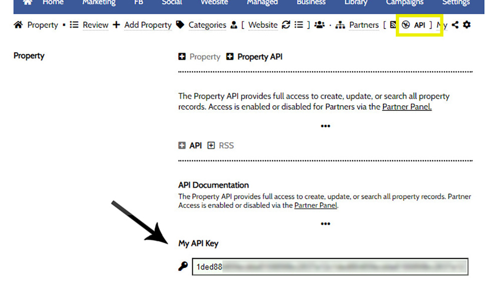
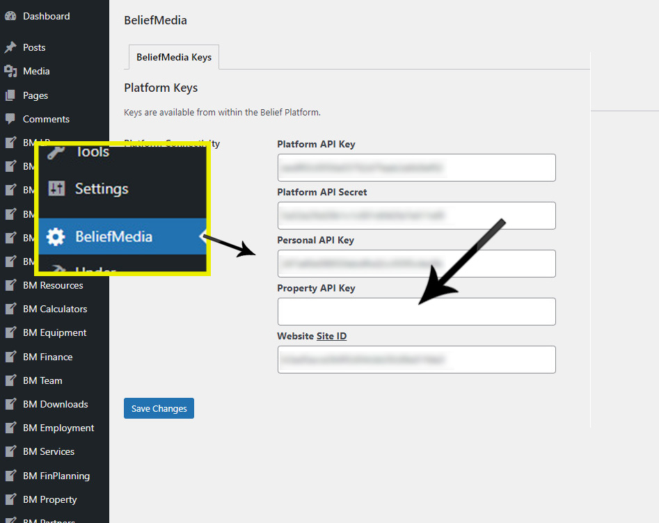
Property API Key: The Property API Key is different to your standard 'Personal' API Key and must be accessed through the Property Module  (and then saved on your website ). The Property Module is a completely standalone module that integrates directly with Yabber. Basic API Documentation introducing the Property API may be found here.If you would like to access the API programmatically, you may reference a basic PHP function here.

Endpoints that return mapping, street coordinate, and spatial data, are not introduced in this FAQ and will instead be documented elsewhere. Many of the responses in this FAQ have already changed, but the full documentation is forthcoming.

The primary purpose of this data on your own website is to facilitate property and suburb reports.

  Introduction

The Streets API is a standard read-only RESTful API providing up-to-date access to every street and registered address in Australia. The street data is made available on client websites from a backend geographic search engine. Data is updated every Monday so we suggest you set any cached data to expire after 3pm on that day. No limitations are applied for general use.

  Property API Endpoint

The Endpoint for all requests to the Property API is structured as follows:

api.beliefmedia.com/property/{category}?/{action}.json?apikey={apikey}

The preferred method of authentication of your API Key is in the Authorisation Header (Authorization: Bearer {token}) as support for the URL parameter will soon be deprecated. Requests to child datasets will always include a {category} while the primary (listing) property endpoint is accessed directly. More information on the Property API is available here.

  Streets API

Queries to the Streets API are made to property/streets/{action}.json with selected action types listed in this FAQ.

  Suburbs

The property/streets/suburbs.json endpoint returns a single response with all Australian suburbs (that include streets). They are indexed on the suburb_id that may be used in various property queries. No URL parameters are accepted.

1
(
2
    [status] => 200
3
    [code] => 200
4
    [data] => Array
5
        (
6
            [1] => Array
7
                (
8
                    [id] => 1
9
                    [suburb] => SOUTHBANK
10
                    [suburb_pretty] => Southbank
11
                    [slug] => southbank
12
                    [suburb_slug] => southbank
13
                    [postcode] => 3006
14
                    [postcode_id] => 431
15
                    [state_id] => 1
16
                    [country_id] => 1
17
                )
18
 
19
            [2] => Array
20
                (
21
                    [id] => 2
22
                    [suburb] => MATRAVILLE
23
                    [suburb_pretty] => Matraville
24
                    [slug] => matraville
25
                    [suburb_slug] => matraville
26
                    [postcode] => 2036
27
                    [postcode_id] => 897
28
                    [state_id] => 2
29
                    [country_id] => 1
30
                )
31
 
32
            [ SNIP ]

The response is quite large. You should request this endpoint with each data update and cache as required. It's highly unlikely that any of the values will change.

  States

The property/streets/states.json endpoint returns a single response with all Australian states and territories. Values are indexed on the state_id that may be used in various property queries. No URL parameters are accepted.

1
(
2
    [status] => 200
3
    [code] => 200
4
    [data] => Array
5
        (
6
            [1] => Array
7
                (
8
                    [id] => 1
9
                    [state] => VIC
10
                    [state_long] => Victoria
11
                    [slug] => vic
12
                    [slug_long] => victoria
13
                    [country_id] => 1
14
                )
15
 
16
            [2] => Array
17
                (
18
                    [id] => 2
19
                    [state] => NSW
20
                    [state_long] => New South Wales
21
                    [slug] => nsw
22
                    [slug_long] => new-south-wales
23
                    [country_id] => 1
24
                )
25
 
26
                [ SNIP ]

  Street Suffix and Street Type

The property/streets/street_suffix.json endpoint returns a single response with all street suffix values, while the The property/streets/street_type.json endpoint returns a single response with all street type values. Values are indexed on the suffix_id and type_id respectively, both of which might be used in various property queries. No URL parameters are accepted.

1
(
2
    [status] => 200
3
    [code] => 200
4
    [data] => Array
5
        (
6
            [1] => WEST
7
            [2] => SOUTH
8
            [3] => NORTH
9
            [4] => EAST
10
            [5] => MALL
11
            [6] => CENTRAL
12
            [7] => EXTENSION
13
            [8] => SOUTH EAST
14
            [9] => DEVIATION
15
            [10] => ON
16
            [11] => SOUTH WEST
17
        )
18
 
19
    [message] => Array
20
        (
21
            [0] => Success
22
        )
23
 
24
)
1
(
2
    [status] => 200
3
    [code] => 200
4
    [data] => Array
5
        (
6
            [1] => ROAD
7
            [2] => STREET
8
            [3] => PARADE
9
            [4] => DRIVE
10
            [5] => CIRCUIT
11
            [6] => WAY
12
            [7] => CRESCENT
13
            [8] => AVENUE
14
            [9] => COURT
15
            [10] => BOULEVARD
16
 
17
                [ SNIP ]

  Stats

The property/streets/stats.json endpoint returns a single response with the total number of addresses, all suburbs with the number of streets in each, and the number of addresses of type. The information is simply for reference in graphing tools and should be cached after each update.

1
(
2
    [status] => 200
3
    [code] => 200
4
    [data] => Array
5
        (
6
            [number_addresses] => 15608317
7
            [addresses_by_locality] => Array
8
                (
9
                    [AARONS PASS] => 53
10
                    [ABBA RIVER] => 39
11
                    [ABBEY] => 737
12
                    [ABBEYARD] => 7
13
                    [ABBEYWOOD] => 37
14
                    [ABBOTSBURY] => 1386
15
                    [ABBOTSFORD] => 11548
16
                    [ABBOTSHAM] => 44
17
                    [ABELS BAY] => 121
18
                    [ABERCORN] => 116
19
                    [ABERCROMBIE] => 513
20
 
21
                    [ SNIP ]
22
 
23
                    [ZETLAND] => 10212
24
                    [ZILLMERE] => 5334
25
                    [ZILZIE] => 1781
26
                    [ZUCCOLI] => 2135
27
                    [ZUMSTEINS] => 6
28
                )
29
 
30
            [addresses_by_type] => Array
31
                (
32
                    [ANTENNA] => 73
33
                    [APARTMENT] => 46931
34
                    [AUTOMATED TELLER MACHINE] => 205
35
                    [BLOCK] => 7
36
                    [BOATSHED] => 1126
37
                    [BUILDING] => 175
38
                    [CARPARK] => 578
39
                    [CARSPACE] => 33973
40
                    [CLUB] => 2
41
                    [COTTAGE] => 1023
42
                    [DUPLEX] => 2573
43
 
44
                    [ SNIP ]
45
 
46
                    [WAREHOUSE] => 1428
47
                    [WORKSHOP] => 30
48
                )
49
 
50
        )
51
 
52
    [message] => Array
53
        (
54
            [0] => Success
55
        )
56
 
57
)

  Locality

The property/streets/locality.json endpoint returns a single response with data relating to a single postcode.

The endpoint requires the parameter of postcode and an optional state (streets/locality.json?postcode=2138&state=nsw). Note that the streets_density_postcode key includes the number of addresses listed on each street. To include all the addresses for a postcode you should include the parameter of &streets=1 (keeping in mind that the response is quite large).

1
(
2
    [status] => 200
3
    [code] => 200
4
    [data] => Array
5
        (
6
            [postcode] => 2138
7
            [state] => NSW
8
            [state_slug] => nsw
9
            [suburbs] => Array
10
                (
11
                    [1476] => Rhodes
12
                    [5261] => Concord West
13
                    [11218] => Liberty Grove
14
                )
15
 
16
            [locality_slugs] => Array
17
                (
18
                    [rhodes] => RHODES
19
                    [concord-west] => CONCORD WEST
20
                    [liberty-grove] => LIBERTY GROVE
21
                )
22
 
23
            [number_addresses] => 11441
24
            [number_streets] => Array
25
                (
26
                    [CONCORD WEST] => 44
27
                    [LIBERTY GROVE] => 21
28
                    [RHODES] => 26
29
                )
30
 
31
            [addresses_by_locality] => Array
32
                (
33
                    [CONCORD WEST] => 2725
34
                    [LIBERTY GROVE] => 913
35
                    [RHODES] => 7803
36
                )
37
 
38
            [po] => Array
39
                (
40
                    [longitude] => 151.0860360000000
41
                    [latitude] => -33.8460980000000
42
                )
43
 
44
            [streets_density_postcode] => Array
45
                (
46
                    [ALFRED STREET] => 3
47
                    [AVERILL STREET] => 19
48
                    [BANGALLA ROAD] => 32
49
                    [BARUNGA STREET] => 3
50
                    [BLAXLAND ROAD] => 86
51
                    [BORONIA STREET] => 43
52
                    [BRADLEY PLACE] => 91
53
                    [BREWER AVENUE] => 14
54
                    [BRUNSWICK AVENUE] => 13
55
                    [BURKE STREET] => 44
56
                    [CASTLESTEAD STREET] => 19
57
                    [CAVELL AVENUE] => 37
58
                    [CAVENDISH STREET] => 44
59
                    [CHARLTON DRIVE] => 66
60
                    [COLANE STREET] => 64
61
                    [COLE CRESCENT] => 27
62
                    [CONCORD AVENUE] => 33
63
                    [CONCORD ROAD] => 398
64
                    [CONNOR CLOSE] => 10
65
                    [CONSETT STREET] => 122
66
                    [CONWAY AVENUE] => 1
67
                    [COONONG ROAD] => 26
68
                    [CROPLEY STREET] => 55
69
                    [CUMMING AVENUE] => 19
70
                    [CURRAWANG STREET] => 53
71
                    [DARLING AVENUE] => 7
72
                    [DENHAM STREET] => 9
73
                    [DONNELLY CLOSE] => 4
74
                    [ELIZA AVENUE] => 9
75
                    [FRAZIER CLOSE] => 9
76
                    [FREMONT STREET] => 29
77
                    [GAUTHORPE STREET] => 124
78
                    [GEORGE STREET] => 38
79
                    [GRACEMERE STREET] => 2
80
                    [HARRISON AVENUE] => 19
81
                    [HEWIN CLOSE] => 16
82
                    [HILLIER STREET] => 1
83
                    [HOMEBUSH BAY DRIVE] => 60
84
                    [HOSPITAL ROAD] => 64
85
                    [IANDRA STREET] => 70
86
                    [JEAN WAILES AVENUE] => 183
87
                    [JOSEPH CLOSE] => 6
88
                    [KILLOOLA STREET] => 37
89
                    [KING STREET] => 45
90
                    [LEEDS STREET] => 45
91
                    [LEWIS AVENUE] => 136
92
                    [LLEWELLYN STREET] => 159
93
                    [LOCH MAREE PARADE] => 19
94
                    [MACKENZIE STREET] => 116
95
                    [MARQUET STREET] => 953
96
                    [MARY STREET] => 304
97
                    [MEPUNGA STREET] => 71
98
                    [MEREDITH AVENUE] => 38
99
                    [MERVILLE STREET] => 39
100
                    [MILL PARK STREET] => 63
101
                    [MOALA STREET] => 55
102
                    [MYALL STREET] => 81
103
                    [NEWTON CLOSE] => 10
104
                    [NINA GRAY AVENUE] => 204
105
                    [NIRRANDA STREET] => 105
106
                    [NULLAWARRA AVENUE] => 26
107
                    [OULTON AVENUE] => 2
108
                    [PEAKE AVENUE] => 142
109
                    [PHOENIX AVENUE] => 15
110
                    [POWELL CLOSE] => 14
111
                    [QUANDONG PLACE] => 23
112
                    [QUANDONG STREET] => 2
113
                    [QUEEN STREET] => 392
114
                    [RIDER BOULEVARD] => 704
115
                    [ROBERTS CLOSE] => 8
116
                    [ROTHWELL AVENUE] => 6
117
                    [SETTLERS BOULEVARD] => 57
118
                    [SEVIER AVENUE] => 80
119
                    [SHORELINE DRIVE] => 1927
120
                    [SIMEON PLACE] => 8
121
                    [STATION AVENUE] => 22
122
                    [STUART STREET] => 208
123
                    [THE DRIVE] => 70
124
                    [THORPE AVENUE] => 90
125
                    [TIMBROL AVENUE] => 433
126
                    [TULLOCH AVENUE] => 16
127
                    [VICTORIA AVENUE] => 135
128
                    [WALKER STREET] => 1970
129
                    [WALLAROY STREET] => 18
130
                    [WENTON AVENUE] => 14
131
                    [WENTWORTH DRIVE] => 432
132
                    [WILGA STREET] => 81
133
                    [WILLIAM CLOSE] => 3
134
                    [WILTSHIRE CLOSE] => 12
135
                    [WUNDA ROAD] => 41
136
                    [YARALLA STREET] => 38
137
                )
138
 
139
            [addresses_by_type] => Array
140
                (
141
                    [CARSPACE] => 2
142
                    [HOUSES] => 2919
143
                    [KIOSK] => 14
144
                    [PENTHOUSE] => 9
145
                    [REAR] => 1
146
                    [SHOP] => 103
147
                    [STORE] => 19
148
                    [SUITE] => 39
149
                    [TOWNHOUSE] => 3
150
                    [UNIT] => 8332
151
                )
152
 
153
            [addresses_by_type_locality] => Array
154
                (
155
                    [rhodes] => Array
156
                        (
157
                            [CARSPACE] => Array
158
                                (
159
                                    [modified_flat_type] => CARSPACE
160
                                    [counts] => 2
161
                                    [locality_name] => RHODES
162
                                    [suburb_slug] => rhodes
163
                                )
164
 
165
                            [KIOSK] => Array
166
                                (
167
                                    [modified_flat_type] => KIOSK
168
                                    [counts] => 14
169
                                    [locality_name] => RHODES
170
                                    [suburb_slug] => rhodes
171
                                )
172
 
173
                            [SHOP] => Array
174
                                (
175
                                    [modified_flat_type] => SHOP
176
                                    [counts] => 103
177
                                    [locality_name] => RHODES
178
                                    [suburb_slug] => rhodes
179
                                )
180
 
181
                            [STORE] => Array
182
                                (
183
                                    [modified_flat_type] => STORE
184
                                    [counts] => 19
185
                                    [locality_name] => RHODES
186
                                    [suburb_slug] => rhodes
187
                                )
188
 
189
                            [TOWNHOUSE] => Array
190
                                (
191
                                    [modified_flat_type] => TOWNHOUSE
192
                                    [counts] => 3
193
                                    [locality_name] => RHODES
194
                                    [suburb_slug] => rhodes
195
                                )
196
 
197
                            [UNIT] => Array
198
                                (
199
                                    [modified_flat_type] => UNIT
200
                                    [counts] => 8332
201
                                    [locality_name] => RHODES
202
                                    [suburb_slug] => rhodes
203
                                )
204
 
205
                        )
206
 
207
                    [concord-west] => Array
208
                        (
209
                            [HOUSES] => Array
210
                                (
211
                                    [modified_flat_type] => HOUSES
212
                                    [counts] => 2919
213
                                    [locality_name] => CONCORD WEST
214
                                    [suburb_slug] => concord-west
215
                                )
216
 
217
                            [REAR] => Array
218
                                (
219
                                    [modified_flat_type] => REAR
220
                                    [counts] => 1
221
                                    [locality_name] => CONCORD WEST
222
                                    [suburb_slug] => concord-west
223
                                )
224
 
225
                        )
226
 
227
                    [liberty-grove] => Array
228
                        (
229
                            [PENTHOUSE] => Array
230
                                (
231
                                    [modified_flat_type] => PENTHOUSE
232
                                    [counts] => 9
233
                                    [locality_name] => LIBERTY GROVE
234
                                    [suburb_slug] => liberty-grove
235
                                )
236
 
237
                            [SUITE] => Array
238
                                (
239
                                    [modified_flat_type] => SUITE
240
                                    [counts] => 39
241
                                    [locality_name] => LIBERTY GROVE
242
                                    [suburb_slug] => liberty-grove
243
                                )
244
 
245
                        )
246
 
247
                )
248
 
249
            [address_by_type_locality_percentage] => Array
250
                (
251
                    [rhodes] => Array
252
                        (
253
                            [CARSPACE] => 0.02
254
                            [KIOSK] => 0.17
255
                            [SHOP] => 1.22
256
                            [STORE] => 0.22
257
                            [TOWNHOUSE] => 0.04
258
                            [UNIT] => 98.34
259
                        )
260
 
261
                    [concord-west] => Array
262
                        (
263
                            [HOUSES] => 99.97
264
                            [REAR] => 0.03
265
                        )
266
 
267
                    [liberty-grove] => Array
268
                        (
269
                            [PENTHOUSE] => 18.75
270
                            [SUITE] => 81.25
271
                        )
272
 
273
                )
274
 
275
        )
276
 
277
    [message] => Array
278
        (
279
            [0] => Success
280
        )
281
 
282
)

  Addresses

The property/streets/addresses.json endpoint returns addresses on a single street. Required URL parameters includes the state_slug (lower-case two or three-letter state representation), street_slug, and postcode. A request to addresses.json?state_slug=nsw&street=moala-street returns something similar to the following:

1
(
2
    [status] => 200
3
    [code] => 200
4
    [data] => Array
5
        (
6
            [11010201] => Array
7
                (
8
                    [property_id] => 11010201
9
                    [street_name] => MOALA STREET
10
                    [state_slug] => nsw
11
                    [state] => NSW
12
                    [suburb_slug] => concord-west
13
                    [postcode] => 2138
14
                    [coordinate] => S33°50′26.88″ E151°5′31.2″
15
                    [flat_type] =>
16
                    [geocode_type] => PROPERTY CENTROID
17
                    [longitude] => 151.092
18
                    [latitude] => -33.8408
19
                    [locality_name] => CONCORD WEST
20
                    [locality_name_slug] => 1-moala-st-concord-west-nsw-2138
21
                    [address_label] => 1 MOALA ST, CONCORD WEST NSW 2138
22
                    [key] => b5c9f6c81cf6aa898831e5e5ec765cdb
23
                )
24
 
25
            [13953203] => Array
26
                (
27
                    [property_id] => 13953203
28
                    [street_name] => MOALA STREET
29
                    [state_slug] => nsw
30
                    [state] => NSW
31
                    [suburb_slug] => concord-west
32
                    [postcode] => 2138
33
                    [coordinate] => S33°50′30.48″ E151°5′31.2″
34
                    [flat_type] =>
35
                    [geocode_type] => PROPERTY CENTROID
36
                    [longitude] => 151.092
37
                    [latitude] => -33.8418
38
                    [locality_name] => CONCORD WEST
39
                    [locality_name_slug] => 10-moala-st-concord-west-nsw-2138
40
                    [address_label] => 10 MOALA ST, CONCORD WEST NSW 2138
41
                    [key] => c90b273c01076ba7d529b055e72f1184
42
                )
43
 
44
            [ SNIP ]
45
 
46
            [1811622] => Array
47
                (
48
                    [property_id] => 1811622
49
                    [street_name] => MOALA STREET
50
                    [state_slug] => nsw
51
                    [state] => NSW
52
                    [suburb_slug] => concord-west
53
                    [postcode] => 2138
54
                    [coordinate] => S33°50′27.96″ E151°5′27.6″
55
                    [flat_type] =>
56
                    [geocode_type] => PROPERTY CENTROID
57
                    [longitude] => 151.091
58
                    [latitude] => -33.8411
59
                    [locality_name] => CONCORD WEST
60
                    [locality_name_slug] => 9-moala-st-concord-west-nsw-2138
61
                    [address_label] => 9 MOALA ST, CONCORD WEST NSW 2138
62
                    [key] => da644f5199d85dcfccb61dc35d951411
63
                )
64
 
65
        )
66
 
67
    [message] => Array
68
        (
69
            [0] => Success
70
        )
71
 
72
)

Note that the 'street slug' is passed as street. The postcode is optional but generally required to avoid the response returning property on the same street in different localities or states. You may mitigate the risk of geographically irrelevant streets with the parameter of street_id.

Note that each property includes a property_id, locality_name_slug, and key. Either of these values may generally be used to query properties when a property_id is required.

  Address

The property/streets/address.json endpoint returns addresses on a single street. The property_id (as noted above) is required. A request to address.json?property_id=11010201 returns something similar to the following:

1
(
2
    [status] => 200
3
    [code] => 200
4
    [data] => Array
5
        (
6
            [property_id] => 11010201
7
            [street_name] => MOALA STREET
8
            [state_slug] => nsw
9
            [locality_name] => CONCORD WEST
10
            [suburb_slug] => concord-west
11
            [postcode] => 2138
12
            [coordinate] => S33°50′26.88″ E151°5′31.2″
13
            [flat_type] =>
14
            [geocode_type] => PROPERTY CENTROID
15
            [longitude] => 151.092
16
            [latitude] => -33.8408
17
            [locality_name_slug] => 1-moala-st-concord-west-nsw-2138
18
            [address_label] => 1 MOALA ST, CONCORD WEST NSW 2138
19
            [distance] => Array
20
                (
21
                    [m] => 0.5
22
                    [k] => 0.8
23
                    [n] => 0.43
24
                )
25
 
26
        )
27
 
28
    [message] => Array
29
        (
30
            [0] => Success
31
        )
32
 
33
)

The locality_name_slug value is generally required when each property is listed on a website and a unique and SEO-friendly URL is required. The distance key returns the distance to the reference Post Office in kilometres, miles, and nautical miles.

  Streets

The property/streets/streets.json endpoint returns paginated addresses on a single street. A postcode, page number, and limit is required (limit is the number of results returned to each page). A request to streets.json?postcode=2138&page=4&limit=3 returns something similar to the following:

1
(
2
    [status] => 200
3
    [code] => 200
4
    [data] => Array
5
        (
6
            [code] => 200
7
            [status] => 200
8
            [page] => 4
9
            [limit] => 3
10
            [number_records] => 11441
11
            [data] => Array
12
                (
13
                    [0] => Array
14
                        (
15
                            [pid] => GANSW718587397
16
                            [address_label] => THE PINNACLE SHOP 10 7 RIDER BVD, RHODES NSW 2138
17
                            [address_site_name] => THE PINNACLE
18
                            [building_name] =>
19
                            [flat_type] => SHOP
20
                            [flat_number] => 10
21
                            [number_first] => 7
22
                            [number_last] =>
23
                            [lot_number] =>
24
                            [street_name] => RIDER
25
                            [street_type] => BOULEVARD
26
                            [street_suffix] =>
27
                            [locality_name] => RHODES
28
                            [state] => NSW
29
                            [postcode] => 2138
30
                            [coordinate] => S33°49′55.2″ E151°5′9.6″
31
                            [geocode_type] => BUILDING CENTROID
32
                            [latitude] => -33.832
33
                            [longitude] => 151.086
34
                            [location] => 3ab663e9a46586ae633c96a723543964
35
                            [suburb_slug] => rhodes
36
                            [locality_name_slug] => the-pinnacle-shop-10-7-rider-bvd-rhodes-nsw-2138
37
                            [bmid] => b1cfb61ec407c74a3c36c9bd3a205fb2
38
                        )
39
 
40
                    [1] => Array
41
                        (
42
                            [pid] => GANSW704435002
43
                            [address_label] => 184 QUEEN ST, CONCORD WEST NSW 2138
44
                            [address_site_name] =>
45
                            [building_name] =>
46
                            [flat_type] =>
47
                            [flat_number] =>
48
                            [number_first] => 184
49
                            [number_last] =>
50
                            [lot_number] => 44
51
                            [street_name] => QUEEN
52
                            [street_type] => STREET
53
                            [street_suffix] =>
54
                            [locality_name] => CONCORD WEST
55
                            [state] => NSW
56
                            [postcode] => 2138
57
                            [coordinate] => S33°50′25.8″ E151°5′9.6″
58
                            [geocode_type] => PROPERTY CENTROID
59
                            [latitude] => -33.8405
60
                            [longitude] => 151.086
61
                            [location] => 38175e273a3c54aa5ceec914cec92163
62
                            [suburb_slug] => concord-west
63
                            [locality_name_slug] => 184-queen-st-concord-west-nsw-2138
64
                            [bmid] => ba5884166839e59f663b16076859db6b
65
                        )
66
 
67
                    [2] => Array
68
                        (
69
                            [pid] => GANSW717909620
70
                            [address_label] => BUILDING D UNIT 612 91 SHORELINE DR, RHODES NSW 2138
71
                            [address_site_name] => BUILDING D
72
                            [building_name] =>
73
                            [flat_type] => UNIT
74
                            [flat_number] => 612
75
                            [number_first] => 91
76
                            [number_last] =>
77
                            [lot_number] =>
78
                            [street_name] => SHORELINE
79
                            [street_type] => DRIVE
80
                            [street_suffix] =>
81
                            [locality_name] => RHODES
82
                            [state] => NSW
83
                            [postcode] => 2138
84
                            [coordinate] => S33°49′27.12″ E151°5′13.2″
85
                            [geocode_type] => BUILDING CENTROID
86
                            [latitude] => -33.8242
87
                            [longitude] => 151.087
88
                            [location] => 37aa696caa50046ffd6216d52c7380b9
89
                            [suburb_slug] => rhodes
90
                            [locality_name_slug] => building-d-unit-612-91-shoreline-dr-rhodes-nsw-2138
91
                            [bmid] => 592df1b3c83da0ca3837cd4e86d71e85
92
                        )
93
 
94
                )
95
 
96
        )
97
 
98
    [message] => Array
99
        (
100
            [0] => Success
101
        )
102
 
103
)

  Suburb

The property/streets/suburb.json endpoint returns all streets in a single locality. The suburb (slug) and state is required. An optional postcode may be provided to limit results to streets within a defined postal region.

A request to suburb.json?suburb=burwood&state=nsw&postcode=2134 returns the following:

1
(
2
    [status] => 200
3
    [code] => 200
4
    [data] => Array
5
        (
6
            [albert-crescent] => Array
7
                (
8
                    [locality_name] => BURWOOD
9
                    [street_name] => ALBERT
10
                    [street_name_slug] => albert-crescent
11
                    [postcode] => 2134
12
                    [street_type] => CRESCENT
13
                    [street_suffix] =>
14
                    [street_name_full] => ALBERT CRESCENT
15
                    [street_id] => 401459
16
                    [suburb_slug] => burwood
17
                    [state_slug] => nsw
18
                    [number_addresses] => 95
19
                    [po] => Array
20
                        (
21
                            [longitude] => 151.1017570000000
22
                            [latitude] => -33.8800490000000
23
                        )
24
 
25
                )
26
 
27
            [angelo-street] => Array
28
                (
29
                    [locality_name] => BURWOOD
30
                    [street_name] => ANGELO
31
                    [street_name_slug] => angelo-street
32
                    [postcode] => 2134
33
                    [street_type] => STREET
34
                    [street_suffix] =>
35
                    [street_name_full] => ANGELO STREET
36
                    [street_id] => 137810
37
                    [suburb_slug] => burwood
38
                    [state_slug] => nsw
39
                    [number_addresses] => 90
40
                    [po] => Array
41
                        (
42
                            [longitude] => 151.1017570000000
43
                            [latitude] => -33.8800490000000
44
                        )
45
 
46
                )
47
 
48
            [ SNIP ]
49
 
50
            [wynne-avenue] => Array
51
                (
52
                    [locality_name] => BURWOOD
53
                    [street_name] => WYNNE
54
                    [street_name_slug] => wynne-avenue
55
                    [postcode] => 2134
56
                    [street_type] => AVENUE
57
                    [street_suffix] =>
58
                    [street_name_full] => WYNNE AVENUE
59
                    [street_id] => 162509
60
                    [suburb_slug] => burwood
61
                    [state_slug] => nsw
62
                    [number_addresses] => 168
63
                    [po] => Array
64
                        (
65
                            [longitude] => 151.1017570000000
66
                            [latitude] => -33.8800490000000
67
                        )
68
 
69
                )
70
 
71
        )
72
 
73
    [message] => Array
74
        (
75
            [0] => Success
76
        )
77
 
78
)

  Radius and Nearest

The property/streets/nearest.json (and similar radius) endpoint returns all streets within a specific radius of a defined geographical position. A property_id OR latitude and longitude reference point is required. A radius in kilometres is also required (although results are returned in metres).

The supplied property_id may be a numeric ID (as returned in various responses), and the key associated with each record, the GA PID. A request to property/streets/nearest.json?id=299062 unwraps something similar to the following:

1
(
2
    [status] => 200
3
    [code] => 200
4
    [data] => Array
5
        (
6
            [0] => Array
7
                (
8
                    [id] => 482
9
                    [locality_name] => WARILLA
10
                    [street_name] => O'REILLY
11
                    [street_name_slug] =>
12
                    [postcode] => 2528
13
                    [distance] => 2.49060702259337
14
                    [street_type] => STREET
15
                    [street_suffix] =>
16
                    [street_name_full] =>
17
                    [street_id] => 0
18
                    [suburb_slug] => warilla
19
                    [state_slug] =>
20
                    [latitude] => -34.5502
21
                    [longitude] => 150.855
22
                    [coordinate] => S34°33′0.72″ E150°51′18″
23
                    [key] =>
24
                )
25
 
26
            [1] => Array
27
                (
28
                    [id] => 5855011
29
                    [locality_name] => WARILLA
30
                    [street_name] => O'REILLY
31
                    [street_name_slug] => o-reilly-street
32
                    [postcode] => 2528
33
                    [distance] => 14.523501583299607
34
                    [street_type] => STREET
35
                    [street_suffix] =>
36
                    [street_name_full] => O'REILLY STREET
37
                    [street_id] => 0
38
                    [suburb_slug] => warilla
39
                    [state_slug] => nsw
40
                    [latitude] => -34.5501
41
                    [longitude] => 150.855
42
                    [coordinate] => S34°33′0.36″ E150°51′18″
43
                    [key] => c0510cbf5c46fbf927a5a94dbebd68a3
44
                )
45
 
46
            [ SNIP ]
47
 
48
            [49] => Array
49
                (
50
                    [id] => 2181506
51
                    [locality_name] => WARILLA
52
                    [street_name] => KING
53
                    [street_name_slug] => king-street
54
                    [postcode] => 2528
55
                    [distance] => 99.45195367680739
56
                    [street_type] => STREET
57
                    [street_suffix] =>
58
                    [street_name_full] => KING STREET
59
                    [street_id] => 0
60
                    [suburb_slug] => warilla
61
                    [state_slug] => nsw
62
                    [latitude] => -34.55
63
                    [longitude] => 150.854
64
                    [coordinate] => S34°33′0″ E150°51′14.4″
65
                    [key] => 4d5fecc5ca785a526ed2d9452ac2aa26
66
                )
67
 
68
        )
69
 
70
    [message] => Array
71
        (
72
            [0] => Success
73
        )
74
 
75
)

  Browse

The property/streets/browse.json endpoint is provided for the purpose of browsing every result in paginated format. The only accepted URL parameters are page, limit, orderby, and order. Exmaple: browse.json?page=3&limt=20&orderby=id&order=asc returns:

1
(
2
    [code] => 200
3
    [status] => 200
4
    [page] => 3
5
    [limit] => 30
6
    [number_records] => 15608317
7
    [pages] => 520278
8
    [data] => Array
9
        (
10
            [0] => Array
11
                (
12
                    [address_details_pid] => GANSW715375607
13
                    [address_label] => UNIT 3801 129 HARRINGTON ST, THE ROCKS NSW 2000
14
                    [address_site_name] =>
15
                    [building_name] =>
16
                    [flat_type] => UNIT
17
                    [flat_number] => 3801
18
                    [level_type] =>
19
                    [level_number] =>
20
                    [number_first] => 129
21
                    [number_last] =>
22
                    [lot_number] =>
23
                    [street_name] => HARRINGTON
24
                    [street_type] => STREET
25
                    [street_suffix] =>
26
                    [locality_name] => THE ROCKS
27
                    [state] => NSW
28
                    [state_slug] => nsw
29
                    [postcode] => 2000
30
                    [geocode_type] => PROPERTY CENTROID
31
                    [longitude] => 151.206
32
                    [latitude] => -33.8626
33
                    [coordinate] => S33°51′45.36″ E151°12′21.6″
34
                    [flat_type_id] => 1
35
                    [level_type_id] => 0
36
                    [street_name_id] => 58
37
                    [street_name_full] => HARRINGTON STREET
38
                    [street_name_full_id] => 61
39
                    [street_name_slug] => harrington-street
40
                    [street_type_id] => 2
41
                    [street_suffix_id] => 0
42
                    [geocode_type_id] => 3
43
                    [suburb_id] => 61
44
                    [state_id] => 2
45
                    [postcode_id] => 57
46
                    [country_id] => 1
47
                    [lat_lng_id] => 58
48
                    [location] => 8e76c5371f24197c87d1a26b0cacde97
49
                    [suburb_slug] => the-rocks
50
                    [locality_name_slug] => unit-3801-129-harrington-st-the-rocks-nsw-2000
51
                    [key] => 4db3636b83012c6bad3fa889e5fd432f
52
                )
53
 
54
            [ SNIP ]
55
 
56
            [29] => Array
57
                (
58
                    [address_details_pid] => GAWA_161040010
59
                    [address_label] => 63 CORMORANT KEY, WANNANUP WA 6210
60
                    [address_site_name] =>
61
                    [building_name] =>
62
                    [flat_type] =>
63
                    [flat_number] =>
64
                    [level_type] =>
65
                    [level_number] =>
66
                    [number_first] => 63
67
                    [number_last] =>
68
                    [lot_number] =>
69
                    [street_name] => CORMORANT
70
                    [street_type] => KEY
71
                    [street_suffix] =>
72
                    [locality_name] => WANNANUP
73
                    [state] => WA
74
                    [state_slug] => wa
75
                    [postcode] => 6210
76
                    [geocode_type] => PROPERTY CENTROID
77
                    [longitude] => 115.652
78
                    [latitude] => -32.6041
79
                    [coordinate] => S32°36′14.76″ E115°39′7.2″
80
                    [flat_type_id] => 0
81
                    [level_type_id] => 0
82
                    [street_name_id] => 85
83
                    [street_name_full] => CORMORANT KEY
84
                    [street_name_full_id] => 90
85
                    [street_name_slug] => cormorant-key
86
                    [street_type_id] => 16
87
                    [street_suffix_id] => 0
88
                    [geocode_type_id] => 3
89
                    [suburb_id] => 90
90
                    [state_id] => 5
91
                    [postcode_id] => 86
92
                    [country_id] => 1
93
                    [lat_lng_id] => 87
94
                    [location] => 76b311151fbff8ecaa0613f6ca6b9e00
95
                    [suburb_slug] => wannanup
96
                    [locality_name_slug] => 63-cormorant-key-wannanup-wa-6210
97
                    [key] => d08f49674233baf930faf78f00d7de0f
98
                )
99
 
100
        )
101
 
102
)

You may orderby on id, name, suburb, postcode, address, or state, and you may order by asc or desc.

  Search

The more popular property/streets/search.json endpoint is provided for the purpose of searching every result in paginated format. You may search on the following values (all are wildcard, so partial matches are accepted):

  • street
  • suburb
  • postcode
  • latitude and longitude
  • state

For example, a request to search.json?street=moala&suburb=concord&postcode=2138 unfold to an array resembling the following:

1
(
2
    [code] => 200
3
    [status] => 200
4
    [page] => 1
5
    [limit] => 30
6
    [number_records] => 55
7
    [pages] => 2
8
    [data] => Array
9
        (
10
            [0] => Array
11
                (
12
                    [address_details_pid] => GANSW704452006
13
                    [address_label] => 27 MOALA ST, CONCORD WEST NSW 2138
14
                    [address_site_name] =>
15
                    [building_name] =>
16
                    [flat_type] =>
17
                    [flat_number] =>
18
                    [level_type] =>
19
                    [level_number] =>
20
                    [number_first] => 27
21
                    [number_last] =>
22
                    [lot_number] => 36
23
                    [street_name] => MOALA
24
                    [street_type] => STREET
25
                    [street_suffix] =>
26
                    [locality_name] => CONCORD WEST
27
                    [state] => NSW
28
                    [state_slug] => nsw
29
                    [postcode] => 2138
30
                    [geocode_type] => PROPERTY CENTROID
31
                    [longitude] => 151.09
32
                    [latitude] => -33.8418
33
                    [coordinate] => S33°50′30.48″ E151°5′24″
34
                    [flat_type_id] => 0
35
                    [level_type_id] => 0
36
                    [street_name_id] => 36421
37
                    [street_name_full] => MOALA STREET
38
                    [street_name_full_id] => 299017
39
                    [street_name_slug] => moala-street
40
                    [street_type_id] => 2
41
                    [street_suffix_id] => 0
42
                    [geocode_type_id] => 3
43
                    [suburb_id] => 0
44
                    [state_id] => 2
45
                    [postcode_id] => 869
46
                    [country_id] => 1
47
                    [lat_lng_id] => 268755
48
                    [location] => 8837d5a1c1556f6d0cd4bb9a0951158e
49
                    [suburb_slug] => concord-west
50
                    [locality_name_slug] => 27-moala-st-concord-west-nsw-2138
51
                    [key] => ef65769eb76cf87ad7a488cde0929522
52
                )
53
 
54
            [ SNIP ]
55
 
56
            [29] => Array
57
                (
58
                    [address_details_pid] => GANSW704435632
59
                    [address_label] => 11 MOALA ST, CONCORD WEST NSW 2138
60
                    [address_site_name] =>
61
                    [building_name] =>
62
                    [flat_type] =>
63
                    [flat_number] =>
64
                    [level_type] =>
65
                    [level_number] =>
66
                    [number_first] => 11
67
                    [number_last] =>
68
                    [lot_number] => 28
69
                    [street_name] => MOALA
70
                    [street_type] => STREET
71
                    [street_suffix] =>
72
                    [locality_name] => CONCORD WEST
73
                    [state] => NSW
74
                    [state_slug] => nsw
75
                    [postcode] => 2138
76
                    [geocode_type] => PROPERTY CENTROID
77
                    [longitude] => 151.091
78
                    [latitude] => -33.8412
79
                    [coordinate] => S33°50′28.32″ E151°5′27.6″
80
                    [flat_type_id] => 0
81
                    [level_type_id] => 0
82
                    [street_name_id] => 36421
83
                    [street_name_full] => MOALA STREET
84
                    [street_name_full_id] => 0
85
                    [street_name_slug] => moala-street
86
                    [street_type_id] => 2
87
                    [street_suffix_id] => 0
88
                    [geocode_type_id] => 3
89
                    [suburb_id] => 0
90
                    [state_id] => 2
91
                    [postcode_id] => 869
92
                    [country_id] => 1
93
                    [lat_lng_id] => 5074952
94
                    [location] => b112dfbd5f266f640acaccf861f7973a
95
                    [suburb_slug] => concord-west
96
                    [locality_name_slug] => 11-moala-st-concord-west-nsw-2138
97
                    [key] => 62e893e7355d6770d2b055e2808c89e8
98
                )
99
 
100
        )
101
 
102
)

You may orderby on id, name, suburb, postcode, address, or state, and you may order by asc or desc.

  Validate and Autocomplete

The address validation endpoint will accept an address and return matching addresses. It may be used via standard GET request but is more typically used asynchronously to provide address suggestions while a user types into a text field. The feature is introduced in an FAQ titled "How to Use the Property Address Validation API and Autocomplete Form on My Website".

Form Address Validation and Autocomplete

The endpoint for the asynchronous or other request is validate.json?q-address=8%20moala%20st%20concord%20west%20nsw%202138.

Both the validate and autocomplete actions are similar with the exception that the validate option provides a facility for header and more information. Up to 20 partial matches are returned in a single response which are ordered based on field priority (street, suburb, postcode etc). The naked query string accepts multiple formats which are interpreted server-side making it suitable for address validation with form submissions.

1
(
2
    [0] => Array
3
        (
4
            [address_details_pid] => GANSW704436209
5
            [address_label] => 8A MOALA ST, CONCORD WEST NSW 2138
6
            [address_site_name] =>
7
            [building_name] =>
8
            [flat_type] =>
9
            [flat_number] =>
10
            [level_type] =>
11
            [level_number] =>
12
            [number_first] => 8A
13
            [number_last] =>
14
            [lot_number] => 4
15
            [street_name] => MOALA
16
            [street_type] => STREET
17
            [street_suffix] =>
18
            [locality_name] => CONCORD WEST
19
            [state] => NSW
20
            [state_slug] => nsw
21
            [postcode] => 2138
22
            [geocode_type] => PROPERTY CENTROID
23
            [longitude] => 151.092
24
            [latitude] => -33.8419
25
            [coordinate] => S33°50′30.84″ E151°5′31.2″
26
            [flat_type_id] => 0
27
            [level_type_id] => 0
28
            [street_name_id] => 36421
29
            [street_name_full] => MOALA STREET
30
            [street_name_full_id] => 0
31
            [street_name_slug] => moala-street
32
            [street_type_id] => 2
33
            [street_suffix_id] => 0
34
            [geocode_type_id] => 3
35
            [suburb_id] => 0
36
            [state_id] => 2
37
            [postcode_id] => 869
38
            [country_id] => 1
39
            [lat_lng_id] => 1053533
40
            [location] => cf2610fda05ceffc72d4239d84cd440e
41
            [suburb_slug] => concord-west
42
            [locality_name_slug] => 8a-moala-st-concord-west-nsw-2138
43
            [hash] => e320ef173903c0e0cf86516c103ff83d
44
        )
45
 
46
    [1] => Array
47
        (
48
            [address_details_pid] => GANSW704436210
49
            [address_label] => 8 MOALA ST, CONCORD WEST NSW 2138
50
            [address_site_name] =>
51
            [building_name] =>
52
            [flat_type] =>
53
            [flat_number] =>
54
            [level_type] =>
55
            [level_number] =>
56
            [number_first] => 8
57
            [number_last] =>
58
            [lot_number] => 2
59
            [street_name] => MOALA
60
            [street_type] => STREET
61
            [street_suffix] =>
62
            [locality_name] => CONCORD WEST
63
            [state] => NSW
64
            [state_slug] => nsw
65
            [postcode] => 2138
66
            [geocode_type] => PROPERTY CENTROID
67
            [longitude] => 151.092
68
            [latitude] => -33.8416
69
            [coordinate] => S33°50′29.76″ E151°5′31.2″
70
            [flat_type_id] => 0
71
            [level_type_id] => 0
72
            [street_name_id] => 36421
73
            [street_name_full] => MOALA STREET
74
            [street_name_full_id] => 0
75
            [street_name_slug] => moala-street
76
            [street_type_id] => 2
77
            [street_suffix_id] => 0
78
            [geocode_type_id] => 3
79
            [suburb_id] => 0
80
            [state_id] => 2
81
            [postcode_id] => 869
82
            [country_id] => 1
83
            [lat_lng_id] => 2524517
84
            [location] => a6ca8a89d143c1051036421011cec907
85
            [suburb_slug] => concord-west
86
            [locality_name_slug] => 8-moala-st-concord-west-nsw-2138
87
            [hash] => 57add4fd10d851fe4a72a04be8528396
88
        )
89
 
90
)

This endpoint cannot be accessed outside whitelisted IP addresses, and a time-limited validation key is required in addition to the standard API Key with each request. This protection is automate on client websites.

The consumer-facing functionality of the endpoint are introduced in an article titled 'How to Use the Property Address Validation API and Autocomplete Form on Your Website'. Another article titled 'Address Autocomplete Form Linking to Dedicated Property Page' shows how to link directly to any of the millions of pages generated with the tool.

  Conclusion

Results on this page were truncated for readability and they should be used for illustrative purposes only. The primary purpose of the API is to link into Yabber's broader property module, but the feature in isolation often provides value.

  Related FAQs

Article relating to the Property API.

The Property Streets API is a means to access registered street and address data from Yabber. For most users, this information isn't necessary nor relevant, but many have technical skills that permits them to integrate various types of data with their existing applications. Other Property FAQs show how to assign property widgets and video to… [ Learn More ]

The Property Emergency Services API is a means to access location information for Australian police stations, ambulance stations, fire stations, and SES facilities. For most users, this API information isn't necessary nor relevant, but many have technical skills that permits them to integrate various types of data with their existing applications. The API itself is… [ Learn More ]

The Property Railway Station API is a means to access the location of Australian railway stations. For most users, this information isn't necessary nor relevant, but many have technical skills that permits them to integrate various types of data with their existing applications. The API itself is used extensively by the Yabber property modules.

Articles relating to the Yabber and Website Property modules.

This FAQ details the methods necessary to create a parent Property API Key. While the Property modules are intrinsically connected with all our modules, it operates autonomously via a standalone API-centric system that connects with multiple external applications. In order to use the Property module, you must first be assigned to the module (which is… [ Learn More ]

In a previous FAQ we looked at how to include an address validation field into a form on your website. This FAQ will introduce the same style of field that will automatically direct the user to the single page associated with each registered address in Australia. This feature is part of the broader Property… [ Learn More ]

The Property Property Streets API, and the Validation Endpoint in particular, is a means to access registered street and registered address location from Yabber via a form input field. The Validation (or Autocomplete) endpoints are useful for searching property on user keystrokes. The validation may be used to ensure pinpoint accuracy is assured by way… [ Learn More ]

SMS Subscription forms may be used in any number of ways, but the primary purpose is to support text message alerts for various types of property opportunities. When the form was first introduced, the form was part of our supporting partner modules, but more and more brokers are becoming affiliate directly with property groups, and… [ Learn More ]

  Related FAQs

BM FAQ Yabber Website

How to Create a Related Video List

The ‘Related Videos’ panel will return a an accordion populated with related video modal links. The Relates Videos are managed in Yabber, so changes to

Share this FAQ

Share on Facebook
Share on Twitter
Share on Linkdin
Share on Pinterest

■ ■ ■

 
Download our complimentary 650-page guide on marketing for mortgage brokers. We'll show you exactly how we generate billions in volume for our clients.
Finance Guide, Cropped Top and Bottom
  Timezone: 1 · [ CHANGE ]