RBA Cash Rate: 4.35% · 1AUD = 0.67 USD · Inflation: 4.1%  
Leading Digital Marketing Experts | 1300 235 433 | Aggregation Enquires Welcome | Book Appointment
Example Interest Rates: Home Loan Variable: 5.69% (5.89%*) • Home Loan Fixed: 5.49% (5.98%*) • Fixed: 5.49% (5.98%*) • Variable: 5.69% (5.89%*) • Investment IO: 5.79% (6.41%*) • Investment PI: 5.69% (6.55%*)

How to Use the Property Emergency Services API

The Property Emergency Services API is a means to access location information for Australian police stations, ambulance stations, fire stations, and SES facilities. For most users, this API information isn't necessary nor relevant, but many have technical skills that permits them to integrate various types of data with their existing applications. The API itself is used extensively by the Yabber property modules.

Property Module: Yabber's Property Module is extensive. The module makes property listing, analytical, and other data available to you, your child users, and partners. A large number of APIs may be used to access data for other applications. Review an introduction to the Property Module here. A commonly referenced FAQ details how to include a Property Listing Widget on your website, and another details how to assign a property to an existing widget location.

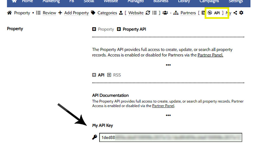
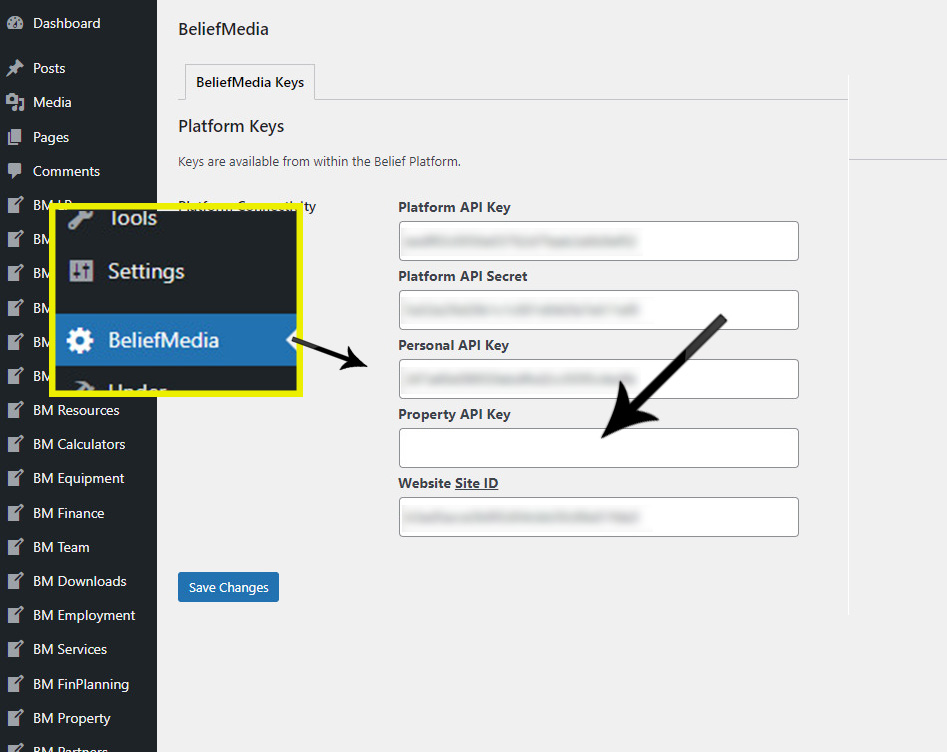
Property API Key: The Property API Key is different to your standard 'Personal' API Key and must be accessed through the Property Module  (and then saved on your website ). The Property Module is a completely standalone module that integrates directly with Yabber. Basic API Documentation introducing the Property API may be found here.If you would like to access the API programmatically, you may reference a basic PHP function here.

  Property API Endpoint

The Endpoint for all requests to the Property API is structured as follows:

api.beliefmedia.com/property/{category}?/{action}.json?apikey={apikey}

The preferred method of authentication of your API Key is in the Authorisation Header (Authorization: Bearer {token}) as support for the URL parameter will soon be deprecated. Requests to child datasets will always include a {category} while the primary (listing) property endpoint is accessed directly. More information on the Property API is available here.

  Introduction

The Emergency API is a standard read-only RESTful API providing up-to-date access to emergency facilities in Australia. All requests will return only police stations unless a source is provided in each request. To instruct the API to return data for a specific emergency type, the integer sources are provided in a comma-delimited string from the following options:

  1. police
  2. ambulance
  3. fire_metro
  4. fire_country
  5. ses

Example: Querying only fire station data will include the url query of &source=3,4.

Data is updated every Monday so we suggest you set any cached data to expire after 3pm on that day. No limitations are applied for general use.

  Postcode

Querying emergency/postcode.json?postcode=2134 will return data as shown below. Note that we're only returning police stations.

1
(
2
    [police] => Array
3
        (
4
            [9e5128f370dc0274b01da719b1701d80] => Array
5
                (
6
                    [facility] => police
7
                    [name] => Burwood Police Station
8
                    [suburb] => BURWOOD
9
                    [postcode] => 2134
10
                    [latitude] => -33.8789
11
                    [longitude] => 151.105
12
                    [coordinates] => S33°52′44.04″ E151°6′18″
13
                    [distance_to_po_k] => 0.32
14
                    [distance_to_po_m] => 0.20
15
                    [distance_to_po_n] => 0.17
16
                    [address] => 9 BELMORE STREET
17
                    [key] => 9e5128f370dc0274b01da719b1701d80
18
                )
19
 
20
        )
21
 
22
)

If we add the source as &source=1,2,3,4,5 the following will be returned.

1
(
2
    [police] => Array
3
        (
4
            [9e5128f370dc0274b01da719b1701d80] => Array
5
                (
6
                    [facility] => police
7
                    [name] => Burwood Police Station
8
                    [suburb] => BURWOOD
9
                    [postcode] => 2134
10
                    [latitude] => -33.8789
11
                    [longitude] => 151.105
12
                    [coordinates] => S33°52′44.04″ E151°6′18″
13
                    [distance_to_po_k] => 0.32
14
                    [distance_to_po_m] => 0.20
15
                    [distance_to_po_n] => 0.17
16
                    [address] => 9 BELMORE STREET
17
                    [key] => 9e5128f370dc0274b01da719b1701d80
18
                )
19
 
20
        )
21
 
22
    [fire_metro] => Array
23
        (
24
            [a74fef7ddf79b1dbc0999d952369b8cb] => Array
25
                (
26
                    [facility] => fire_metro
27
                    [name] => Burwood
28
                    [suburb] => BURWOOD
29
                    [postcode] => 2134
30
                    [latitude] => -33.8801
31
                    [longitude] => 151.102
32
                    [coordinates] => S33°52′48.36″ E151°6′7.2″
33
                    [distance_to_po_k] => 0.02
34
                    [distance_to_po_m] => 0.01
35
                    [distance_to_po_n] => 0.01
36
                    [address] => 12 LIVINGSTONE STREET
37
                    [key] => a74fef7ddf79b1dbc0999d952369b8cb
38
                )
39
 
40
        )
41
 
42
)

If multiple stations of any type are in the same postal region, multiple results will obviously be returned. A request to emergency/postcode.json?postcode=2134&source=1,2,3,4,5 returns the following.

1
(
2
    [police] => Array
3
        (
4
            [6d793c3ffd835d3c673f3d2ca5f170d7] => Array
5
                (
6
                    [facility] => police
7
                    [name] => Day Street Police Station
8
                    [suburb] => SYDNEY
9
                    [postcode] => 2000
10
                    [latitude] => -33.8753
11
                    [longitude] => 151.204
12
                    [coordinates] => S33°52′31.08″ E151°12′14.4″
13
                    [distance_to_po_k] => 1.66
14
                    [distance_to_po_m] => 1.03
15
                    [distance_to_po_n] => 0.89
16
                    [address] => 192 DAY STREET
17
                    [key] => 6d793c3ffd835d3c673f3d2ca5f170d7
18
                )
19
 
20
            [09d6489462e9507a5bea7ddb9c39c29c] => Array
21
                (
22
                    [facility] => police
23
                    [name] => Afp - Nsw - Sydney Office
24
                    [suburb] => SYDNEY
25
                    [postcode] => 2000
26
                    [latitude] => -33.8782
27
                    [longitude] => 151.21
28
                    [coordinates] => S33°52′41.52″ E151°12′36″
29
                    [distance_to_po_k] => 2.11
30
                    [distance_to_po_m] => 1.31
31
                    [distance_to_po_n] => 1.14
32
                    [address] => 110 GOULBURN STREET
33
                    [key] => 09d6489462e9507a5bea7ddb9c39c29c
34
                )
35
 
36
            [f2987a7a094b338467b430927d4c4aac] => Array
37
                (
38
                    [facility] => police
39
                    [name] => The Rocks Police Station
40
                    [suburb] => THE ROCKS
41
                    [postcode] => 2000
42
                    [latitude] => -33.8595
43
                    [longitude] => 151.209
44
                    [coordinates] => S33°51′34.2″ E151°12′32.4″
45
                    [distance_to_po_k] => 0.69
46
                    [distance_to_po_m] => 0.43
47
                    [distance_to_po_n] => 0.37
48
                    [address] => 1 GLOBE STREET
49
                    [key] => f2987a7a094b338467b430927d4c4aac
50
                )
51
 
52
        )
53
 
54
    [fire_metro] => Array
55
        (
56
            [e9f2bfb8bd2f1448dddf86ae88ce9ff6] => Array
57
                (
58
                    [facility] => fire_metro
59
                    [name] => The Rocks
60
                    [suburb] => MILLERS POINT
61
                    [postcode] => 2000
62
                    [latitude] => -33.8619
63
                    [longitude] => 151.204
64
                    [coordinates] => S33°51′42.84″ E151°12′14.4″
65
                    [distance_to_po_k] => 0.27
66
                    [distance_to_po_m] => 0.17
67
                    [distance_to_po_n] => 0.15
68
                    [address] => 166 KENT STREET
69
                    [key] => e9f2bfb8bd2f1448dddf86ae88ce9ff6
70
                )
71
 
72
            [39d9d92acaa367d9634db12866a43b1a] => Array
73
                (
74
                    [facility] => fire_metro
75
                    [name] => City Of Sydney
76
                    [suburb] => SYDNEY
77
                    [postcode] => 2000
78
                    [latitude] => -33.8752
79
                    [longitude] => 151.209
80
                    [coordinates] => S33°52′30.72″ E151°12′32.4″
81
                    [distance_to_po_k] => 1.77
82
                    [distance_to_po_m] => 1.10
83
                    [distance_to_po_n] => 0.96
84
                    [address] => 211-217 CASTLEREAGH STREET
85
                    [key] => 39d9d92acaa367d9634db12866a43b1a
86
                )
87
 
88
        )
89
 
90
)

For all examples we'll simply query police stations for brevity. Paginated results will include the source in the resulting array (they will not be index on the facility type).

  Suburb

Querying emergency/suburb.json?suburb=sydney&state=nsw&source=1 will unfold as shown below. The state is generally required in name-based requests to exclude interstate facilities.

1
(
2
    [police] => Array
3
        (
4
            [6d793c3ffd835d3c673f3d2ca5f170d7] => Array
5
                (
6
                    [facility] => police
7
                    [name] => Day Street Police Station
8
                    [suburb] => SYDNEY
9
                    [postcode] => 2000
10
                    [latitude] => -33.8753
11
                    [longitude] => 151.204
12
                    [coordinates] => S33°52′31.08″ E151°12′14.4″
13
                    [distance_to_po_k] => 1.66
14
                    [distance_to_po_m] => 1.03
15
                    [distance_to_po_n] => 0.89
16
                    [address] => 192 DAY STREET
17
                    [state] => NEW SOUTH WALES
18
                    [key] => 6d793c3ffd835d3c673f3d2ca5f170d7
19
                )
20
 
21
            [09d6489462e9507a5bea7ddb9c39c29c] => Array
22
                (
23
                    [facility] => police
24
                    [name] => Afp - Nsw - Sydney Office
25
                    [suburb] => SYDNEY
26
                    [postcode] => 2000
27
                    [latitude] => -33.8782
28
                    [longitude] => 151.21
29
                    [coordinates] => S33°52′41.52″ E151°12′36″
30
                    [distance_to_po_k] => 2.11
31
                    [distance_to_po_m] => 1.31
32
                    [distance_to_po_n] => 1.14
33
                    [address] => 110 GOULBURN STREET
34
                    [state] => NEW SOUTH WALES
35
                    [key] => 09d6489462e9507a5bea7ddb9c39c29c
36
                )
37
 
38
        )
39
 
40
)

The distance_to_po_{k|m|n} field returns the distance from that facility to the suburb post office.

  Nearest and Radius

Those facilities nearest to a geographical reference point will be returned in a standard format. The reference point may be a 'key' (as returned with each result), a postcode, or a latitude and longitude.

We'll query nearest.json?longitude=141.799&latitude=-37.8584&radius=50000&source=1,2,3,4,5 (using a latitude and longitude) with a result as follows:

1
(
2
    [status] => 200
3
    [code] => 200
4
    [data] => Array
5
        (
6
            [police] => Array
7
                (
8
                    [f3f9e524d27cf46793a597487ac280b6] => Array
9
                        (
10
                            [facility] => police
11
                            [name] => Branxholme Police Station
12
                            [suburb] => BRANXHOLME
13
                            [postcode] => 3302
14
                            [latitude] => -37.8584
15
                            [longitude] => 141.799
16
                            [coordinates] => S37°51′30.24″ E141°47′56.4″
17
                            [distance_to_po_k] => 8.21
18
                            [distance_to_po_m] => 5.10
19
                            [distance_to_po_n] => 4.43
20
                            [address] => 87-89 MONROE STREET
21
                            [state] => VICTORIA
22
                            [key] => f3f9e524d27cf46793a597487ac280b6
23
                            [distance] => 0.0215382
24
                        )
25
 
26
                )
27
 
28
            [fire_country] => Array
29
                (
30
                    [fd67069091244790e4fb6dba73a85352] => Array
31
                        (
32
                            [facility] => fire_country
33
                            [name] => Branxholme Fire Station Cfa
34
                            [suburb] => BRANXHOLME
35
                            [postcode] => 3302
36
                            [latitude] => -37.8578
37
                            [longitude] => 141.798
38
                            [coordinates] => S37°51′28.08″ E141°47′52.8″
39
                            [distance_to_po_k] => 8.11
40
                            [distance_to_po_m] => 5.04
41
                            [distance_to_po_n] => 4.38
42
                            [address] => 94 BEST STREET
43
                            [state] => VICTORIA
44
                            [key] => fd67069091244790e4fb6dba73a85352
45
                            [distance] => 0.115755
46
                        )
47
 
48
                )
49
 
50
        )
51
 
52
    [message] => Array
53
        (
54
            [0] => Success
55
            [sources] => 1,2,3,4,5
56
        )
57
 
58
)

  Browse

The browse endpoint returns paginated results of all referenced source types. The query string should include page (page number), limit (number of results), order (asc or desc), and orderby ('id', 'name', 'suburb', 'postcode', 'address', or 'state').

Querying emergency/browse.json?page=3&limit=10&orderby=id&order=asc&source=1 unfolds as follows:

1
(
2
    [status] => 200
3
    [code] => 200
4
    [data] => Array
5
        (
6
            [code] => 200
7
            [status] => 200
8
            [page] => 3
9
            [limit] => 10
10
            [number_records] => 1569
11
            [pages] => 157
12
            [data] => Array
13
                (
14
                    [0] => Array
15
                        (
16
                            [facility] => police
17
                            [name] => Boolarra Police Station
18
                            [suburb] => BOOLARRA
19
                            [postcode] => 3870
20
                            [latitude] => -38.3804
21
                            [longitude] => 146.272
22
                            [coordinates] => S38°22′49.44″ E146°16′19.2″
23
                            [distance_to_po_k] => 7.61
24
                            [distance_to_po_m] => 4.73
25
                            [distance_to_po_n] => 4.11
26
                            [address] => 29 TARWIN STREET
27
                            [state] => VICTORIA
28
                            [key] => 1d557d95322b0e6514866a459ae3c8ec
29
                        )
30
 
31
                    [1] => Array
32
                        (
33
                            [facility] => police
34
                            [name] => Boort Police Station
35
                            [suburb] => BOORT
36
                            [postcode] => 3537
37
                            [latitude] => -36.1161
38
                            [longitude] => 143.723
39
                            [coordinates] => S36°6′57.96″ E143°43′22.8″
40
                            [distance_to_po_k] => 4.52
41
                            [distance_to_po_m] => 2.81
42
                            [distance_to_po_n] => 2.44
43
                            [address] => 4 STATION STREET
44
                            [state] => VICTORIA
45
                            [key] => 87f544b5bba7c10d528472cb4898055a
46
                        )
47
 
48
                    [2] => Array
49
                        (
50
                            [facility] => police
51
                            [name] => Boronia Police Station
52
                            [suburb] => BORONIA
53
                            [postcode] => 3155
54
                            [latitude] => -37.8599
55
                            [longitude] => 145.285
56
                            [coordinates] => S37°51′35.64″ E145°17′6″
57
                            [distance_to_po_k] => 0.21
58
                            [distance_to_po_m] => 0.13
59
                            [distance_to_po_n] => 0.11
60
                            [address] => 259 DORSET ROAD
61
                            [state] => VICTORIA
62
                            [key] => 592d29a1b33702b9e970908ec8790045
63
                        )
64
 
65
                    [ SNIP ]
66
 
67
                    [9] => Array
68
                        (
69
                            [facility] => police
70
                            [name] => Apsley Police Station
71
                            [suburb] => APSLEY
72
                            [postcode] => 3319
73
                            [latitude] => -36.9671
74
                            [longitude] => 141.084
75
                            [coordinates] => S36°58′1.56″ E141°5′2.4″
76
                            [distance_to_po_k] => 10.75
77
                            [distance_to_po_m] => 6.68
78
                            [distance_to_po_n] => 5.80
79
                            [address] => 17 SPLATT STREET
80
                            [state] => VICTORIA
81
                            [key] => 3025fd28abeccef0c49a318f6db2d8c0
82
                        )
83
 
84
                )
85
 
86
        )
87
 
88
    [message] => Array
89
        (
90
            [0] => Success
91
        )
92
 
93
)

  Search

You may use the more common search endpoint to filter on name (of the facility), state, postcode, or suburb. The page, limit, orderby, and order parameters may also be passed to paginate results.

Querying search.json?name=cro&page=1&limit=10&orderby=id&order=asc&source=1&source=1,2,3,4,5 unfolds as a paginated response resembling the following (the query is one on the partial match of 'cro'):

1
(
2
    [status] => 200
3
    [code] => 200
4
    [data] => Array
5
        (
6
            [code] => 200
7
            [status] => 200
8
            [page] => 1
9
            [limit] => 10
10
            [number_records] => 18
11
            [pages] => 2
12
            [data] => Array
13
                (
14
                    [0] => Array
15
                        (
16
                            [facility] => police
17
                            [name] => Croydon Police Station
18
                            [suburb] => CROYDON
19
                            [postcode] => 3136
20
                            [latitude] => -37.7992
21
                            [longitude] => 145.279
22
                            [coordinates] => S37°47′57.12″ E145°16′44.4″
23
                            [distance_to_po_k] => 2.17
24
                            [distance_to_po_m] => 1.35
25
                            [distance_to_po_n] => 1.17
26
                            [address] => 171-175 MT DANDENONG ROAD
27
                            [state] => VICTORIA
28
                            [key] => f3d6123e7682a95f95d8ab09a090ac2c
29
                        )
30
 
31
                    [1] => Array
32
                        (
33
                            [facility] => police
34
                            [name] => Cronulla Police Station
35
                            [suburb] => CRONULLA
36
                            [postcode] => 2230
37
                            [latitude] => -34.0513
38
                            [longitude] => 151.152
39
                            [coordinates] => S34°3′4.68″ E151°9′7.2″
40
                            [distance_to_po_k] => 4.88
41
                            [distance_to_po_m] => 3.03
42
                            [distance_to_po_n] => 2.63
43
                            [address] => 34 KINGSWAY
44
                            [state] => NEW SOUTH WALES
45
                            [key] => 42cf27efc5612670aa936869bc053c42
46
                        )
47
 
48
                    [2] => Array
49
                        (
50
                            [facility] => police
51
                            [name] => Crookwell Police Station
52
                            [suburb] => CROOKWELL
53
                            [postcode] => 2583
54
                            [latitude] => -34.4565
55
                            [longitude] => 149.468
56
                            [coordinates] => S34°27′23.4″ E149°28′4.8″
57
                            [distance_to_po_k] => 34.94
58
                            [distance_to_po_m] => 21.71
59
                            [distance_to_po_n] => 18.85
60
                            [address] => 33 GOULBURN STREET
61
                            [state] => NEW SOUTH WALES
62
                            [key] => 7725ebc9328bef2d166a1648240de9d9
63
                        )
64
 
65
                    [ SNIP ]
66
 
67
                    [9] => Array
68
                        (
69
                            [facility] => fire_metro
70
                            [name] => Crows Nest
71
                            [suburb] => CROWS NEST
72
                            [postcode] => 2065
73
                            [latitude] => -33.8282
74
                            [longitude] => 151.2
75
                            [coordinates] => S33°49′41.52″ E151°12′0″
76
                            [distance_to_po_k] => 0.72
77
                            [distance_to_po_m] => 0.45
78
                            [distance_to_po_n] => 0.39
79
                            [address] => 99 SHIRLEY ROAD
80
                            [state] => NEW SOUTH WALES
81
                            [key] => 925ef6d7e446071488264895e159f978
82
                        )
83
 
84
                )
85
 
86
        )
87
 
88
    [message] => Array
89
        (
90
            [0] => Success
91
        )
92
 
93
)

Note: An autocomplete endpoint is also provided to search addresses.

  Conclusion

Like many of the backend APIs we use as part of the Property architecture, the API in isolation - while it provides good up-to-date information - is one that may not be overly useful. However, we do provide an emergency services search facility on client websites that references this API exclusively.

  Related Property API FAQs

Article relating to the Property API.

The Property Streets API is a means to access registered street and address data from Yabber. For most users, this information isn't necessary nor relevant, but many have technical skills that permits them to integrate various types of data with their existing applications. Other Property FAQs show how to assign property widgets and video to… [ Learn More ]

The Property Emergency Services API is a means to access location information for Australian police stations, ambulance stations, fire stations, and SES facilities. For most users, this API information isn't necessary nor relevant, but many have technical skills that permits them to integrate various types of data with their existing applications. The API itself is… [ Learn More ]

The Property Railway Station API is a means to access the location of Australian railway stations. For most users, this information isn't necessary nor relevant, but many have technical skills that permits them to integrate various types of data with their existing applications. The API itself is used extensively by the Yabber property modules.

  Related Property FAQs

Article relating to the Yabber and Website Property modules.

This FAQ details the methods necessary to create a parent Property API Key. While the Property modules are intrinsically connected with all our modules, it operates autonomously via a standalone API-centric system that connects with multiple external applications. In order to use the Property module, you must first be assigned to the module (which is… [ Learn More ]

In a previous FAQ we looked at how to include an address validation field into a form on your website. This FAQ will introduce the same style of field that will automatically direct the user to the single page associated with each registered address in Australia. This feature is part of the broader Property… [ Learn More ]

The Property Property Streets API, and the Validation Endpoint in particular, is a means to access registered street and registered address location from Yabber via a form input field. The Validation (or Autocomplete) endpoints are useful for searching property on user keystrokes. The validation may be used to ensure pinpoint accuracy is assured by way… [ Learn More ]

SMS Subscription forms may be used in any number of ways, but the primary purpose is to support text message alerts for various types of property opportunities. When the form was first introduced, the form was part of our supporting partner modules, but more and more brokers are becoming affiliate directly with property groups, and… [ Learn More ]

  Related FAQs

Share this FAQ

Share on Facebook
Share on Twitter
Share on Linkdin
Share on Pinterest

■ ■ ■

 
Download our complimentary 650-page guide on marketing for mortgage brokers. We'll show you exactly how we generate billions in volume for our clients.
Finance Guide, Cropped Top and Bottom
  Timezone: 1 · [ CHANGE ]